


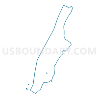
Voting District 6600052, New York County, New York
About
Outline

Summary
| Unique Area Identifier | 632028 |
| Name | Voting District 6600052 |
| County | New York County |
| State | New York |
| Area (square miles) | 0.01 |
| Land Area (square miles) | 0.01 |
| Water Area (square miles) | 0.00 |
| % of Land Area | 100.00 |
| % of Water Area | 0.00 |
| Latitude of the Internal Point | 40.72623060 |
| Longtitude of the Internal Point | -73.98485530 |
Maps

Graphs
Select a template below for downloading or customizing gragh for Voting District 6600052, New York County, New York


Neighbors
Neighoring Voting District (by Name) Neighboring Voting District on the Map
- Voting District 6400048 6400049, New York County, NY
- Voting District 6600050, New York County, NY
- Voting District 6600051, New York County, NY
- Voting District 6600054, New York County, NY
- Voting District 7400020, New York County, NY
- Voting District 7400021, New York County, NY
- Voting District 7400023, New York County, NY
Top 10 Neighboring County Subdivision (by Population) Neighboring County Subdivision on the Map
Top 10 Neighboring Place (by Population) Neighboring Place on the Map
Top 10 Neighboring Unified School District (by Population) Neighboring Unified School District on the Map
Top 10 Neighboring State Legislative District Lower Chamber (by Population) Neighboring State Legislative District Lower Chamber on the Map
- Assembly District 66, NY (140,310)
- Assembly District 64, NY (136,671)
- Assembly District 74, NY (133,261)